TALES OF OUR TRAVELS AND OUR LOVE OF ADVENTURE

Monday, July 26, 2010

Canyons of the Ancients National Monument - Part 1


I missed the creation of this monument.  It was created 10 years ago, and takes up most of the southwest corner of Colorado (west and northwest of Cortez). For many, many years, only little Hovenweep National Monument existed, with several ancient sites to visit in Utah and Colorado.  But this new monument, administered by the Bureau of Land Management (Hovenweep falls under the National Park Service), has over 6,000 documented sites, and the experts are sure there are many more.

I recommend that you start your visit at the Anasazi Heritage Center, a relatively new museum and visitor center built on the hillside above Dolores and McPhee Reservoir.  


This is the Dominguez Pueblo (named for Father Dominguez of the Dominguez-Escalante Expedition of 1776). It's right in front of the Anasazi Heritage Center. Built around 1123 A.D., it had three rooms and a kiva and housed a family of 3-4.

We spent over an hour in the museum - it is full of artifacts from the local area, especially all the settlements that were excavated before they were covered up by the creation of McPhee Reservoir, along with numerous other exhibits.  We were impressed by how nice this museum and visitor center was. 

Before we left the museum, we hiked up to the top of the hill behind it to the Escalante Pueblo (I bet you can guess who that's named for...). It's a half mile hike with only 100 feet of elevation gain on a paved path.  

About halfway up the hill you get a good view of Sleeping Ute Mountain southwest of Cortez.  The highest peak is his folded arms, and you can see his feathered headdress spread out to the right. There are a couple of small volcanic dikes at the southern (left) end, which represent his feet.  

 Also at the top, you have a nice view of McPhee Reservoir.


 One edge of the Escalante Pueblo, at the top of the hill.

The Escalante Pueblo had 28 rooms, along with the kiva (below).

A kiva  is a subterranean room usually used for ceremonial purposes.


 From there, our next stop was Lowry Pueblo. It's a short drive up the 491 (which I remember as the 666 - but it was renamed due to pressure from religious fanatics) to Pleasant View, then 9 miles west on a mostly-paved road. The last 3 miles are good gravel.  There are six very nice picnic tables in the trees, and some restrooms. 
The Lowry Pueblo was initially constructed around AD 1060, and was inhabited for about 165 years.  

It started with just a few rooms and a kiva, but continued to expand. By the time it was abandoned, Lowry Pueblo had 40 rooms, eight kivas, and the Great Kiva.

One of the rooms along the side of the pueblo.


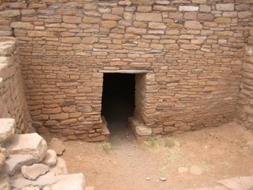
This little door allows visitors to enter the inside of the pueblo, which is currently covered by a huge wood and metal roof to protect it from the elements. 


This kiva is known as the Painted Kiva, as it used to have intricate designs painted on the walls. They're gone now, though a portion was successfully removed and is in the museum.

This is the firepit in the kiva.
One last view of Lowry Pueblo.


Once back outside, a short trail takes you to the Great Kiva - one of the largest ever found - which the experts believe was used for large gatherings instead of private ceremonial events.
I couldn't get all of it in one shot!


These two stone figures were mysteries to archaelogists until a Hopi visitor informed them that they represented Winter and Summer People.

Mmmm Mmmm! Olathe Sweet Corn


First of all, I'd like to welcome follower #21, Wayne of Wayne's RV Travel Blog.  Wayne and his wife Maureen are on their way to becoming full-time RV'ers, and will be doing it in a 22-foot trailer.

Second, I wanted to show you what we had with our hot dogs last night - Olathe sweet corn.  One of the highlights of being in Colorado during the summer is the corn.  It's famous.  It's soooo good!  And right now it's 5 for $1.  So we ate 5. 

Sunday, July 25, 2010

Hello from Priest Gulch


Site #92 at Priest Gulch Campground.  It's not ON the Dolores River, but about 50 feet away from it. 
There's a row of sites right on the river.

Friday morning we enjoyed a last cup of coffee and breakfast at Ridgway State Park, and then leisurely packed up and left for Priest Gulch.  It's only 72 miles, so we didn't have to hurry at all.  The route took us up and over the Dallas Divide (the high country just north of the Sneffels Range), down to Placerville on the San Miguel River, then past Telluride, up and over Lizard Head Pass, and down to Rico. It's then 11 more miles to Priest Gulch Campground.

We stopped in Rico for lunch - there used to be a cafe/grill next to an old theater, and many years ago they made wonderful hamburgers.  It's now closed; another grill a few doors down didn't open until noon (it was 11 am). We looked across the street, and noticed the Mine Shaft Inn, which had a coffee shop/tiny restaurant in front - it had a big sign in the window that said "FOOD."  What a pleasant surprise this place was. Think of bed and breakfast without the breakfast.  There are tables for 3-4 in the front room, then down the hall past one of the bedrooms is a kitchen with tables for 6 more people. We were greeted by the very friendly proprietor, who made us fresh coffee in a French press. It was soooo good.  The food was limited:  tamales, quiches, or burritos.  It comes from the Hi Desert Bakery in Dolores, and is organic.  Don had a beef enchilada quiche, and I had a broccoli quiche that had black olives and chilies in it. The couple who came in right after us had one of the tamales and one of the burritos, and we noticed they both were substantial in size.

After we came out of the inn, we noticed the darkening skies - and realized we'd better get on to Priest Gulch so we wouldn't have to set up in the rain.  We made it just in time!  We pulled into our site, got unhitched and leveled, and had just enough time to plug in the electricity and pull out the awning before the rain began.  We experienced the biggest thunderstorm of the summer so far - huge, loud crashes of lightning and thunder and a driving rain that forced us inside since it was coming under the awning. The storm lasted about an hour - the roads of the campground turned into rivers and most of us had little lakes under our rigs.  After it was all over our neighbor across the street motioned us over to come look at the river.


This area of southwest Colorado is on the southeastern edge of the Colorado Plateau - which as many of you know, has lots of red sandstone. The Dolores River runs through several miles' worth of those red sandstones between Rico and Priest Gulch - and when the area gets heavy rains like it did Friday, the river runs RED. It has cleared now, and Don has had two successful trips upstream to do some fishing. There are many small feeder creeks, too - and we'll take a couple days to give them a try.


This is the very pretty view out our back window. There's a large patch of purple flowers (which are not Columbines but very similar).

We're going to be here until the 3rd of August - which is the day we head for home. Tomorrow we're going to go visit some Indian ruins - Hovenweep and Canyons of the Ancients National Monuments are southwest of here, with access to some of them by passenger car.

I'd like to welcome two more followers to Wanderlust - Amanda of Amanda's Veranda,  and Rod and Loyce  of Retired Rod.  Thanks for being interested in my writings! 

Tuesday, July 20, 2010

Black Canyon of the Gunnison National Park

Since we are camped only about 30 miles from Black Canyon of the Gunnison National Park, we decided to spend the morning there yesterday. It's a quick zip up the 550 to Montrose, then a few miles east on the 50 to the turnoff for the park. You make your way up a good-sized ridge (the edge of the Gunnison Uplift), pay your $15 entrance fee, and drive to the first overlook.

View east from Tomichi Point, the first viewpoint you get to after you enter the park.

One of the views from Gunnison Point, near the Visitor Center

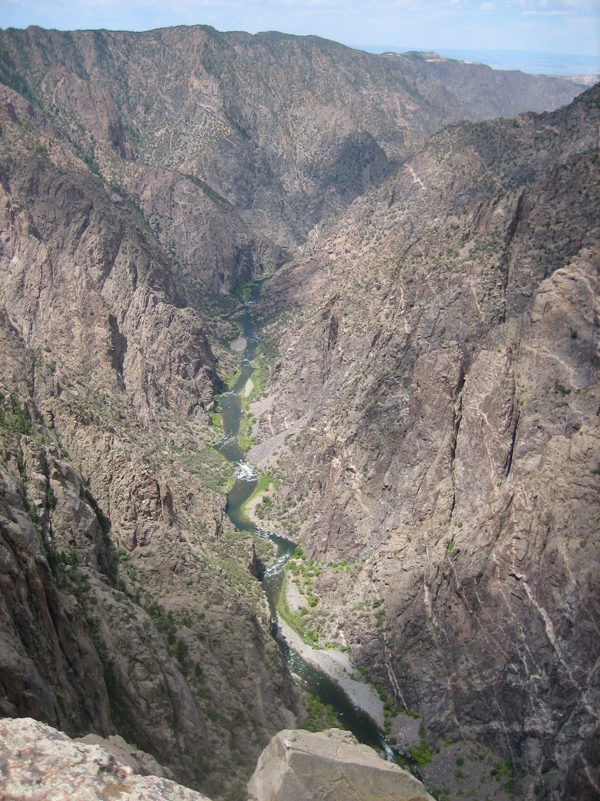
Looking down at the Gunnison River in the bottom of the canyon.

Another view of the Gunnison River

The canyon wall just north of the Visitor Center

Looking east from Gunnison Point

Looking down from Chasm View - this is where the canyon walls are closest together. A ranger who had just finished a geology talk (darn, we missed it!) said the North Rim is only 1100' away.

Looking northwest from Sunset View.  You can see the western edge of Grand Mesa, along with two  geological curiosities:  the uncomformity above the gneiss/monozonite and below the Entrada sandstone and Red Canyon.  The unconformity means that millions of years of rock were worn away on top of the gneiss/monozonite before the thin Entrada sandstone layer was laid down.  You can barely see a portion of the Entrada at the top left at the center of the ridge, and another part of it at top right.

View from Cedar Point


We did NOT plan the lookalike blue shirts.


View west from Painted Wall View

This gnarled juniper reminded me of a bristlecone pine


The Painted Wall.  It looks like this because molten pegmatite, the pinkish rock, came up and filled all the cracks in the gneiss.  It solidified, making the wall even more impermeable.  


By the time we'd finished viewing all the viewpoints - some with nice hikes to get to them - it was 12:30 and blazingly hot.  We drove back into Montrose and enjoyed a nice lunch and lots of iced tea at Applebees before returning to our campsite in Ridgway.  And, of course, Don spent another successful evening on the river.

Dallas Creek

July 17

It's just has hot here as it is in many parts of the country - and while we have electricity and can run the air, it's much nicer to head to high country so Don can fish and I can relax in the shade with a good book.  We'd read in our little fishing guide that upper Dallas Creek had a small lake - so we decided to go up there. Dallas Creek's source is a cirque below Mt. Sneffels, so the road goes all the way up to the Blue Lakes trailhead. 

Mt. Sneffels, 14,150'
We were unable to find the lake - which turned out to be a beaver pond we saw on our way back down - so we stopped at Willow Swamp Campground so Don could fish Dallas Creek.  It isn't really a campground - just a parking area with dispersed places for people to set up, and Willow Swamp really isn't a swamp - it's a gorgeous meadow that runs along Dallas Creek.

Looking south over Willow Swamp towards Mt. Sneffels.  

We stopped in the clearing just to the left of the middle center.  I put my chair out in the shade and chased the shade for two hours.  After lunch I told Don he had about one more hour until I lost the shade up on the hillside (can't put my chair on a slope!).  It was hot, even at that altitude, so shade was a must.

He caught lots of fish - so it was yet another successful day!

Owl Creek Pass

July 16
Like I've said in a previous post, I've always wanted to see "what's on the other side."  In this case, it's Owl Creek Pass, east of Ridgway.  Owl Creek Pass is famous for having several scenes from the movie True Grit shot here.  It's also considered by many to be one of the prettiest drives in Southwest Colorado, especially in the fall when the aspen are turning.

We saw in our book about fly fishing southwestern Colorado that the upper forks of the Cimarron River had some nice places to fish, so Don packed up his gear, I made a snacky lunch, and we took off.  The road is dirt, and rough in some places, but it's maintained for passenger cars. About halfway up there's a viewpoint - where I insisted Don stop so I could take a photo of the Sneffels Range to the southwest.

Picture this area dotted with golden aspen in the fall.  Mt. Sneffels is the large peak in the center left.


Aspen and more aspen.  Millions of them.

Chimney Rock near the top of Owl Creek Pass.


When we came down off Owl Creek Pass we took a right turn up the West Fork of the Cimarron River.  About two miles up, we found a nice spot where Don could do some fishing, and I put my chair under some trees to read and cross stitch while he fished.  This is the view south up the creek. I believe the name of the mountain in the center is Comb Ridge.

This was my view across the creek from my chair.  So nice!

Don caught (and released) several small fish in this creek.  After a couple of hours we drove down the road to look at the Middle and East Forks - and ended up at Silver Jack Reservoir.  There's only one spot where you can get down to the reservoir - and it takes you to some muddy flats that didn't interest Don at all.  

From there we continued north along the Cimarron River, and found the best fishing at Big Cimarron Campground right along the river.  Another couple of hours there and we were done for the day.  Instead of going back upriver and over Owl Creek Pass, we drove north (and downriver) to Highway 50 - which we took into Montrose and then got on the 550 back to Ridgway SP.

Ridgway State Park - best site

The best site in Ridgway State Park, in our opinion,  is the one we're in.  Yes, I've seen people post on forums about how nice it is at Dakota Terraces or Elk Ridge, but our site, #254 in Pa-Co-Chu-Pak, has got to be the best.  Here's why:  first of all, it's at the end of the loop, with no one next to us.  We face out into a large field that has a seldom-used pavilion in it.  Every morning we've been here, we take our coffee outside and watch the deer come out of the creekbed to the east and slowly make their way to the river and back.  One of the deer has a fawn that trots along after her.  So nice.  We're also close to the trail that goes down to the river - so Don only has to go about 75 yards to the water.  The sites that look like they're on the river are actually on bluffs above it - with steep dropoffs.  This site has the river access that Don needs.

Silverton - one of my favorite places

July 14

While Creede is definitely my favorite little Colorado town, Silverton is high on my list of favorite places to go.  It stems from my college days - every year I'd take a minimum course load at Texas Tech, and work as many hours as I could at Furr's Supermarket in order to a) pay for the previous summer's gas, and b) pay for the coming summer's food and expenses. (I'd used gas credit cards.)  As soon as final exams were over in May I'd hit the road for Colorado, and several summers I took the train out of Durango or Silverton and head for the Weminuche Wilderness.  There was one summer I'd planned to hike the Continental Divide Trail from Monarch Pass to Wolf Creek Pass, and had a resupply cached upriver from Silverton.  [Dad started that hike with me, but both of us were turned back due to heavy snow in the Cochetopa Hills - and we learned that it was even worse at the higher elevations.]  But we still ended up in Silverton anyway, since I had to go back and get the cache and the food and cash in it.

The last time we were in Silverton was in 1991 - Don, the kids, and I were camped on the West Dolores, with train reservations. Dad was supposed to meet us at our campground the next evening, but he surprised us by meeting us in Silverton. That visit, and that town, still hold special memories for us.


The drive south out of Ouray takes you up into a deep canyon first - the beginning of the Bear Creek National Scenic Trail and the Alpine Loop are there.  You come out into a wide valley, with a view to the south of the four Red Mountains.  They were heavily mined in the late 1800s - there were SIX towns strung along this valley  ending with the town of Red Mountain at the top of the pass. 


Some more mountain scenery along the way.

Red Mountain #4 and the heart of the Red Mountain Mining District


When we arrived in Silverton, our first stop was the Museum.  It's been greatly expanded since they were given the old jail building, and it has a exhibits on mining and local history.


An old ore bucket


Two grinding machines. Notice the bicycle-type seats for sitting and spinning the grinding wheels.


Old wagon for hauling supplies


We strolled up and down the main street of Silverton for a while, and stopped for lunch at Handlebars - the same place we'd had lunch with Dad back in 1991.


Don was intrigued by this old halftrack sitting in front of the VFW Hall.


This is Arrastra Gulch, which was heavily mined for many years. The Silver Lake Mine is up in the center, and there's an aerial tramway from the top of the gulch down to the stamp mill in the Animas valley.  Not only did the tramway move buckets of ore, but miners rode in the buckets - sort of like we ride ski lifts today.


This is the stamp mill - currently undergoing renovation to be turned into a money-making enterprise giving tours to tourists.

A few more hours in Silverton and we headed back north towards Ridgway.  Along the way we stopped for about an hour at Crystal Lake, where Don unsuccessfully fished for some of the many trout we saw in the water.


A very pretty little lake; the fish just weren't biting.
This is typical of many streams in the Red Mountain area - the red colorization from the mine tailings.

We continued on our way, getting back to Ridgway in time to eat a cold dinner of cereal (what I love to eat when it's hot outsides) and for Don to go fishing on the Uncompahgre.  He fishes that river every evening - there's a two-mile stretch through the park below the dam that is full of trout. It's artificial flies/lures only, catch-and-release, so the trout population remains stable with lots of big ones.