TALES OF OUR TRAVELS AND OUR LOVE OF ADVENTURE

Wednesday, July 14, 2010

A Day in Ouray

Ouray is called "The Switzerland of America." While its elevation is not that high (a little over 8,000'), it's ringed by very high mountains and is just a lovely setting for a town. It's rich in mining history, and is now fancied by tourists, cyclists, bikers, hikers, and climbers. It's at the northern terminus of the Million Dollar Highway - a twisting, climbing highway that runs from Durango to Silverton to Ouray.

Don and I have not been to Ouray before- we stayed in the Ouray KOA one night in 1991, but it's south of town and we never went into town. The last time I'd been there (without him) was in 1976, and I barely remember it; I'm sure it's changed a lot in 35 years.

The first thing we did was what we call "being tourists." We parked the truck at one end of the main street, and spent a couple hours walking up and back, stopping in whatever stores caught our fancy. We stopped for coffee at Mouse's Chocolate and Coffee, and walked out with a bag of their famous "Scrap Cookies." They take a bunch of cookie dough, probably a typical chocolate cookie recipe, and chop up all kinds of leftover scraps from the candy making. The cookies have anything and everything - dried fruit, chocolate, caramel, nuts, coconut, and bit of different fillings from the fancy chocolates. They are absolutely delicious - and it's quite fun being surprised at what you're going to get from each one.

Next we visited Box Canyon Falls. These are southwest of town, and drop several hundred feet through a fissure in the rocks caused by some major faulting.   After you pay your $5 entrance fee, you have two choices of trails:  the High Bridge Trail and the Falls Trail.  I always like to get the more difficult trail out of the way first, so we took the High Bridge Trail. First, you climb up a bunch of iron stairs, then a rocky trail that takes you several hundred feet above the falls and canyon.  


Looking upstream from near the High Bridge.


Looking northeast towards the town of Ouray from near the High Bridge.

The tunnel leads to a portion of the Ouray Perimeter Trail - a high-altitude hike that goes around the entire town.  You can't get back to the parking lot from here, so we didn't take it.


Instead, we hiked back down (I love going down!) and took the Falls Trail into the box canyon from which the falls are named.  You can't see the entire waterfall because it comes down a rock chute - but you can hear it thundering. 

The base of the falls.


Looking downstream from the base of the falls - see the old mining equipment up on the right?


This is looking straight up at the High Bridge.


Coming back up, we noticed this sign, so we started looking.  

Sure enough, not more than 10 feet from the trail was this nest with a large swift sitting on her eggs.


From Box Canyon Falls we drove over to the southeast side of town to check out Amphitheater Campground.  We discovered that it's really not for motor homes or trailers longer than 25' - though the camp host had gotten a large fifth wheel up there.  There's a narrow road that climbs the side of the mountain to get to it, so narrow that two vehicles would really have a large time passing each other without one having to stop and/or back up.  There are maybe 5-6 campsites that a trailer could fit into - and there was a sign leading to the main part of the campground stating "small cars only."  It's definitely a tents and pop-up campground.

We ate lunch under a large tree at a trailhead, and then went to see Cascade Falls. These are east of town  and accessible via a short (1/4 mile) walk.  


Right after Don took that picture, we turned to walk back down to the truck.  I was on a gently-sloping section of the trail and hit a patch of loose gravel. My right foot went out from under me, and all my weight landed on my left knee and hand.  There wasn't a lot of blood, but it sure does sting!


I'm currently at a Starbuck's in Montrose - I had to come pick up a prescription and decided to get caught up with internet stuff here since Starbuck's now has free WiFi.

Monday, July 12, 2010

Taylor Park to Ridgway

July 11

Our last morning in Taylor Park.  Since we didn't have a long way to go, we were able to spend some time in chairs enjoying the view while we had our coffee.  Almost every morning the lake made it's own little cloud, which floated off down the canyon by around 8 am. 

We are now camped at Ridgway State Park; things are quite different here. We're over 2,000 feet lower; the temperatures are much warmer.  We will most likely have to run the air conditioner every day; last night it didn't cool down until 9pm.  I"m at Cimarron Books and Coffee in Ridgway, using their free WiFi - again, I'm out of AT&T coverage to use my iPhone's internet and related apps.  I think they're going to get to know me pretty well the next 12 days!

We plan to go to Ouray, Silverton, Owl Creek Pass, and a few other places while we're here.  Don can fish the Uncompahgre River by walking 30 yards from our campsite.  So I can leave him there while I come to town.

Until later!

Kebler Pass and Lake Irwin - my 54th birthday

This is the view looking west from the top of Kebler Pass.

That's Don again, in his float tube on Lake Irwin.  It's a heavily used little lake just north of Kebler Pass. It has a 38-site Forest Service campground - with 6 bathroom buildings to clean and just one pair of camp hosts.  I spoke with them for a little bit - they were clearly overwhelmed with the task and a bit put off by the Forest Service's unwillingness to give them any help. They were expected to be there all the time; when they asked their supervisor about going to town to do laundry, check mail, use the internet, make phone calls, etc., they were told to squeeze in time when they could.  I don't think they'll be doing this campground next summer! 

We had another great day here - though around 1 it got really cold and windy - and I felt like I was sitting right in a wind tunnel. So I went to sit in the car; about an hour later Don came in because he was cold and wet (it had started to rain.) 

We next headed back down to Crested Butte, where we spent a couple hours shopping before dinner,
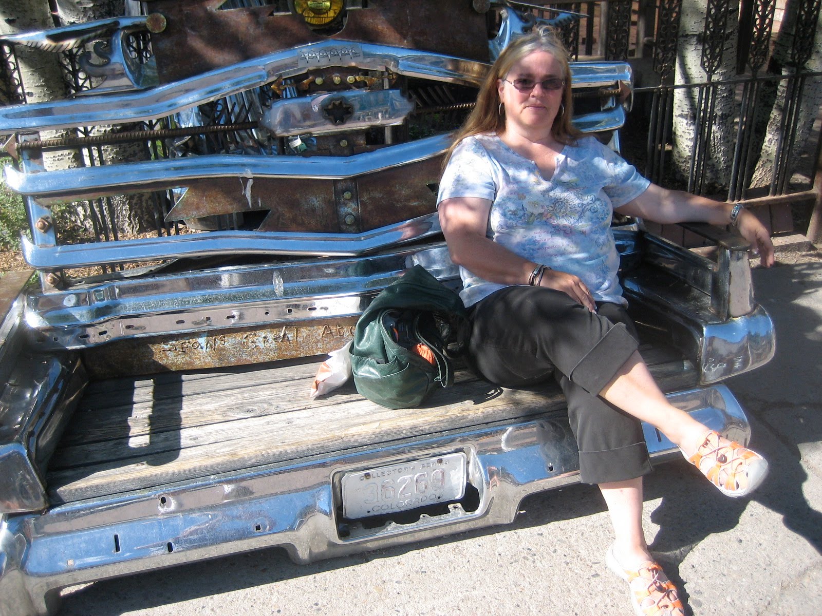
This unique bench is made of old car bumpers and assorted other parts.

Dinner was at Timberline - and it was fabulous. I had filet mignon; Don had duck cassoulet. I discovered a new wine that I just love - it's a sweet riesling from Pacific Rim. 

Old Irwin Cemetery

July 10

Yes, I know the sign says "Erwin," but it is spelled Irwin on on the maps. This little cemetery is at the top of Kebler Pass, west of Crested Butte. We came up to see the pass before we went fishing at Lake Irwin, and saw the sign for this old cemetery.

"The bright promise of ruby silver drew 5,000 people to this area in 1879. From as far as England and Scotland, Irwin became a ghost town when silver was demonitized in 1884. This cemetery was known as Ruby Camp Cemetery in 1879. It was renamed Irwin Cemetery in 1880.  Approximately 50 burials were made here before it was abandoned in 1885."

While the monument above says it was abandoned, there are numerous recent burials, along with several markers commemorating the scattering of ashes.

This is one of the older burials; a woman named Mary who died in 1881.


This set of markers brought tears to my eyes. The bottom left is the gravestone of a former soldier who died in 1976. The marker on the top right is that of his wife, who lived much longer than he did - she died in August of 2009 and is buried next to him here. The poem on the marker at the top was written by (or quoted by) their daughter, Linda. "Where the wind was blowing across a high place... Where the air was thin and full of silver sounds and coyotes with bright yellow eyes..I smelled owls & sagebrush & small wild things. The whole universe was alive. Vibrating all around that high windy place and there was no more fear,, because my father lives here."


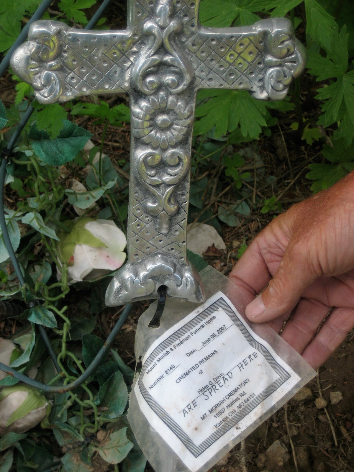
Attached to this silver cross is a tag from a mortuary certifying that this person's ashes were scattered in this area.

This is a little box that used to hold Betty Holden's ashes. It's just sitting on the ground here.

Another more recent burial.

Next to this marker, held down by the rocks, is the man's hat.  The marker reads "If tears could build a stairway, and memories a lane, I'd walk right up to heaven and bring you back again."


Later today we were walking up Elk Avenue in Crested Butte, and Don noticed Rozman Realty.

The End of the Road, and Spring Creek Reservoir

July 8

There are two things I have always wanted to see:
1.  What's at the end of the road, and
2. What's on the other side.

This was a drive to see both. First, we drove as far up the Taylor River road as we could - about 30 miles.  It ended in this valley, where a hiking trail continued further up the river.


Up here the river is pretty small - a creek, really, but Don still investigated for possible fishing.


I turned around and took this photo looking back downriver.


We stopped for about an hour for Don to do a little fishing; he caught a couple small brook trout.

From here we drove up to "the other side" of the mountain that sits on the west side of Taylor Reservoir. Our destination was Spring Creek Reservoir - about the same size as Mirror Lake, and also with a campground next to it. This one (Mosca) is well-used since there's easy access from the city of Gunnison. Don put his float tube in, and only came out a couple of times when we got some rain showers. We stayed there until nearly 5 pm. It was another wonderful day of relaxation.

That's Don - the small orange dot in each photo.

I don't want to go back to California.

Bon Ton Mine (below Cumberland Pass)

On the way down the south side of Cumberland Pass is the old mining "town" of Bon Ton. There were a few ruins that were left; Don and I have always enjoyed finding things like this,


Cumberland Pass

If you head south out of Tincup, instead of east to Mirror Lake, a pretty good gravel road takes you up and over Cumberland Pass. You end up in Pitkin, and from there can either reverse your trip or continue down to Highway 50 and go back to Taylor Park via Gunnison. That's the route we took, since we wanted to eat lunch in Gunnison and pick up a couple of things at the store in town.

The first picture above is as we were nearing the top of the pass - it's in the center of the photo.

Looking southeast from Cumberland Pass - the Continental Divide is the ridge in the distance.

Dad used to take pictures of me next to the pass signs, so I had Don take this one to continue the tradition.

Can you tell the wind was howling up here?  It was pretty cold at over 12,000'.

Even at 12,000' there are signs of mining activity!

Looking back down the Willow Creek valley towards Tincup and Taylor Park.


A small patch of windblown, stunted pines at the top of the pass.

Mirror Lake

About 15 miles southeast of Taylor Park, past the old mining town of Tincup, is Mirror Lake. It sits at 11,000 feet, and has a small Forest Service campground (with no water). It's also one of Don's favorite lakes to float.  He caught several dozen fish - mostly rainbows, but a few brookies, and I sat and read and cross stitched.  It was a wonderful way to spend the day.

Taylor Park -watching the weather

One of our favorite "activities" was actually sitting in our chairs and watching the weather. Since the Collegiate Range is about 20 miles north of us, we could see the storms move from southwest to northeast (left to right) across Taylor Park.  Many times we never got the rain - it just moved across the valley.

Catching Up: Taylor Park - June 29-30

Location: Cimarron Books and Coffee Shop, Ridgway, Colorado


While I've been using only my iphone for posting, and have had very little internet access with my laptop, I didn't notice until today that Wanderlust has three more followers:
Dixxe's Doodles - Dixxe has a blog she calls My Life-Art-Photography
Heidi - a fulltimer in a VAN, with her husband. Read about it in Vantramps
and Laura, who as far as I know doesn't have a blog.
Welcome to all three; I hope my writings about my travels and plans for the future continue to interest you.


We stayed at Taylor Park in the Lakeview Forest Service campground on a hill above the south end of Taylor Park Reservoir.  Above is the view we had from our site.  The peaks in the distance are the Collegiate Peaks - beyond them is Aspen. 


This is a HUGE herd of cattle we encountered on our way up the Taylor River above Almont. There were several hundred of them, all walking up the highway, crossing willy-nilly back and forth and holding up traffic for miles.  Of course, the mess they left was not good for our truck and trailer, either.


This is the upper Taylor River, about 10 miles north of the reservoir.  This section is considered Gold Medal trout water - and Don spent many days on this part of the river while we were in Taylor Park.

Sunday, July 4, 2010

4th of July in Crested Butte

 Mount Crested Butte


Now this was an unexpected surprise. We went to Crested Butte to go to
the Farmers' Market, but stumbled on a parade along with thousands of
people.
I blame an insufficiently-maintained Chamber of Commerce website. I
did my research-I visited several different Crested Butte websites,
including the C of C one, and not one of them said anything about a
parade. I saw the pancake breakfast, the weekly Farmers' Market, and
the fireworks, but definitely not the parade. Now why is this a big
deal to me?
I really dislike crowds.
And as we neared Crested Butte, we saw that traffic was backed up on
the highway just to get into town. We finally figured it out when we
saw a sign directing parade floats to the starting area.
We found a parking place-not a bad one; and first made our way to the
market. We then went up Elk Avemue, the main street of Crested Butte,
which also just happened to be the parade route. Both sides of the
street were 3 to 5 people deep, and at least half of them had dogs.
(Don't get me wrong-I love dogs-but I've never seem so many in one
place at one time!). There was also a food court, with everything you
could want: barbecue, hot dogs and burgers, teriyaki chicken, falafel,
udon bowls, lamb kebabs and kibbe, Italian sausage, kettle corn,
roasted corn, turkey legs, and gyros. Don had a pork barbecue
sandwich, and I had a beef one.
We resumed our shopping after the parade was over, and then headed
back to the truck for the trip back to Taylor Park.
Our haul for the day: cherries, organic artisan raisin bread,
pastries, Keen shoes for me, a wide-brimmed fishing hat for Don, beer,
cheese, asparagus, crimini mushrooms, a new bead/gem for my watch, a
cheese grater, lemon-pepper seasoning, and a bottle of Mountain View
Winery (Olathe) Gewurztraminer.
We've noticed that many of the weekend campers have gone home. It's
really nice to be back in OUR home, where it's not wall-to-wall people.

Saturday, July 3, 2010

Posting via my iPhone

Greetings from Taylor Park, Colorado, where we're camped in site #66
in the Lakeview Campground. We have electric hookups, and the water
spigot is close enough to this site that we were able to use our Water
Thief and rum a hose to fill up our fresh water tank. The dump station
is 5 miles away but at least there IS one. We have a breathtaking view
of the lake and the entire valley--ringed by the Collegiate Peaks and
the Sawatch Range. I'll post pics when I have Internet access again.
I'm doing a post for the first time via email-I'd forgotten that I
could do that or I'd have done it earlier.

Don is in fishing heaven-he's caught rainbows out of the upper Taylor
River, rainbows and brook trout out of Willow Creek and Mirror Lake,
and yesterday he caught a huge pike while float tubing in the lake.

I've done some sewing, some reading, and a lot of TV-watching. My
excuse for that is that both the World Cup and Wimbledon are on. I
went with Don to Mirror Lake and read a bit while watching him float
the lake all day. I'm glad I brought sunscreen with me-the sun burns
pretty brightly at 11,000 feet!

The weather has been wonderful-scattered thundershowers and lots of
sun. Since we have this magnificent view, we can watch the
thundershowers move across the valley 20 miles away. We know Aspen is
about 30 miles due north over the Collegiate Peaks, and when we see
the distant lightning, we know it's over Aspen.

Tomorrow we're going to the Farmers' Market in Crested Butte. We both
have a craving for fresh asparagus again, and I'll look for more nice
fruits and veggies to eat next week. I also like to walk up and down
Elk Acenue and visit the shops. They have a good shoe store there that
carries Keens, so maybe I'll see if they have the thong sandals I like
so much.

Until next time!