TALES OF OUR TRAVELS AND OUR LOVE OF ADVENTURE

Friday, December 20, 2013

December 19 - Willcox & Chiricahua National Monument

We moved today - about 50 miles to the northeast to the town of Willcox.  We're in a small RV park called Fort Willcox, far enough from the 10 to not hear the trucks and far enough from the tracks to not be bothered by the passing trains.

We were watching the weather forecast - our plans had been to go to Chiricahua National Monument on Friday - but with a major storm coming in, we decided to go after we set the trailer up. But first, lunch.  We'd gotten a recommendation in Bisbee to make sure we ate at the rail car.  Big Tex BBQ is built around a real railroad car, and we both had the barbecue brisket sandwich.  It was huge!  And good.

We then drove southeast to Chiricahua National Monument - a place that's always been on our bucket list. We stopped at the Visitor Center, where we saw a little film and the exhibits. We learned that the formations were created from volcanic ash.  A huge volcano had erupted, and the ash was compressed into rock over the eons. Then fissures and cracks formed, and water eroded the rocks, leaving the hoodoo-like formations.

Next, we drove the 8-mile drive up to Massai Point, where we walked a short nature trail.  We didn't stay out long - it was really windy, and I didn't have earmuffs or a hat, and my ears started aching horribly. So we took lots of pictures at the top and on the way back down. 


Sugarloaf Mountain - looks a lot like the Sugarloaf on the 38 going to Big Bear

Cochise Head - looks just like him!


Thursday, December 19, 2013

December 18 - Coronado National Memorial & Fort Huachuca

We visited two places today that were relevant to significant parts of the history of the United States, especially the Southwest.   First up was the Coronado National Memorial, south of Sierra Vista and really close to the Mexican border.

Those of you who know me well know that I attended two high schools - the first was in Germany, and then the one from which I graduated - Coronado High School in Lubbock, Texas.  Our school was named for the Spanish explorer Francisco Vasquez de Coronado, who led an expedition through the Southwest in search of the Seven Cities of Gold. He never found them, and was apparently misled by the Indians to look out on the Great Plains. He got as far as Kansas, and either on the way there or on the way back, he passed through the Llano Estacado, or the "staked plains" of western Texas and eastern New Mexico.  I remember seeing a few roadside historical markers about the expedition passing through that area.

 We're just outside the memorial here, and we'll end up at the top of that canyon in the left center.


First, we stopped at the Visitor Center, where we watched a short film about the expedition, viewed the exhibits, and had a short talk with the ranger on duty. We found out that the National Park Service creates Parks and Monuments named after people and places, and Memorials are named for events. I learned that the expedition really didn't come to this canyon, but did go north up the nearby San Pedro River corridor. I asked her, "Why here?" since I wondered how the memorial ended up in this canyon. The answer had to do with the woman responsible for the eventual creation of the memorial, and her donation of the land for it.

Next, we drove west up the canyon - one mile on a paved road, and then two steep and winding miles on an unpaved road - to the top of Montezuma Pass (6575').  From there, you can look south and southeast into Mexico, along with the clearly defined border fence built a few years ago.

View southwest into Mexico

Looking southeast towards Mexico. The straight dark line is the border fence.

View back east down Montezuma Canyon


From Montezuma Pass there are several hiking opportunities.  If we were through-hikers on the Arizona Trail, which runs from just below here on the Mexican Border all the way up to Utah - we could head north up into the Huachuca Mountains. If we had a way to get back to our truck up here, we could take Joe's Trail 3 miles across a ridge and back down to the Visitor Center. If you're interested instead in a short hike, you can do what we did - climb to the top of nearby Coronado Peak (6864').  It was just 300' of elevation gain in about half a mile - not that hard (but I did get nicely winded). 
Heading up the trail

Looking west towards southern Arizona

The cholla was blooming

Looking south from the top into Mexico

At the top

At the top

At the top

Don decided to head down the Yuma Trail a little - this is the southernmost portion of the Arizona Trail, and ends up at the Mexican border less than a mile away.


Border Patrol agent parked along the fence


After a couple drinks of water, we headed back down the canyon and drove north to Fort Huachuca. Today, Fort Huachuca is a fairly big Army base, complete with several housing areas, a commissary and PX, and all the amenities of today's military bases. But this one has a history that began in the late 1800's as the American government waged its "Indian Wars" and worked to expand westward. The westernmost portion of the base is the original post - with the original parade ground, officer's quarters, enlisted quarters, and other buildings. We started at the main building of the museum which lies adjacent to the sloping parade grounds.  We learned about the two regiments of Buffalo Soldiers who served at Ft. Huachuca, along with numerous other soldiers who achieved fame - Pershing, Patch, and La Guardia, to name a few.


Museum main building


Yes, this picture is straight. It's the parade grounds that are sloping from left to right.


Part of a display about family life at the old Fort


The original officers' quarters are still being used. This one is directly across from the museum

Statue commemorating the Apache scouts

Next door to the museum is the Annex, housed in what used to be a theater. There are more exhibits about the Fort - some are set up as life-sized soldiers, horses, and wagons.


Walking around a museum always hurts my back (from all the standing) so we left and went back to our campsite.  There we enjoyed another mild evening and gorgeous sunset.


December 17 - Bisbee

I've heard a lot of good things about Bisbee, so that was a place we'd wanted to go. It was only about 45 miles away - a quick trip through Tombstone and then up into the Bisbee Mountains. We got there around 10, and found that the Visitor Center was inside the Queen Mine building. So we parked there to start our day.
Queen Mine building, Bisbee in in the background
We decided to take a quick tour of Bisbee on foot first, and then do the Queen Mine Tour later.  So we walked into town (all of about 100 yards away) and looked around at the various stores and unique buildings.

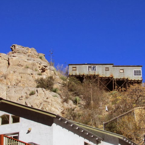
This building up on top of the hill looked like it was made of tin and was going to rust away pretty soon.

A tight squeeze for two lanes on this main street through town!  We stopped for coffee at Bisbee Coffee - relaxed there for a bit and decided that we'd take the Queen Mine Tour before we had lunch. So we walked back to the Queen Mine building, paid for our tour ($13 each), and got fitted out in hard hats, yellow slickers, belts, and lamps.  There were only 4 of us for the noon tour; we sat on little train seats that we had to straddle.  At first I was behind the other man in the group; I then moved to have a place to lean back.


Getting ready to enter the mine. Notice the sign - 1915 was when this particular tunnel was dug.

Our tour guide worked in the mine when he was in his teens, and showed us a couple of photos of him back then - early 1970s.


That's Don in front of me, holding on for dear life as we went further into the tunnel.


Here we got off and walked down that tunnel.  We went 1500 feet into the mountain, according to the guide.


In case of emergency in the tunnel we were in, this was the evacuation tunnel. It came out somewhere else on the mountain.


These are the ends of chutes from the levels above us, where ore would drop down into the buckets on the rails and then get carted out of the mine.


 Don and the other couple on the tour listen to the guide. That's the assistant in the rear. 


Several different kinds of drills - used for drilling holes in the rock that would be then stuffed with dynamite and blown up to keep expanding the working area.


Explosives were hauled in this red cart.


This elevator was used to carry 9 miners at a time from level to level, as well as to bring up ore from lower levels.

More carts for hauling ore.


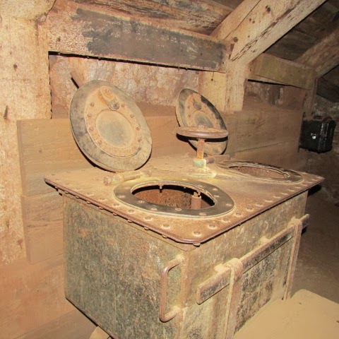
Imagine using a two seater - I mean, doing your business while someone else is also doing his right next to you!


After the tour was over, we went back to town, were I discovered Bisbee Olive Oil.  I'd seen a business like that in Creede, Colorado.  They have a large number of different flavors of olive oil and balsamic vinegars to taste, as well as some soaps and body care products. We tasted balsamic vinegars, and I bought two - one is an 18-year "regular" flavor (divine - thick, sweet, and oh so good) and the other is Chili (spicy and sweet at the same time).  Since we like them with bread and basic olive oil, we decided not to get any expensive oil.

The woman in the olive oil shop recommended The Table for lunch - and we are so glad we listened to her.  Don had the Ancho Reuben - the mustard was spicy and he said it was the best Reuben he'd ever had. He had sweet potato fries, and gobbled them up! I had the Bleu and Black - a hamburger that had bleu cheese and grilled red onions on it - nothing more. The meat was delicious, and I almost inhaled it, it was so good. I was in the mood for fruit, so I skipped the fries and had a fruit mixture. Tasty.


We made it back to the campground in time to see the sun casting the last light on the Dragoons off to the northeast.
Don and I sat out for a while, enjoying the mild weather.


And then we enjoyed another brilliant Arizona sunset.