Today is a get-ready-for-going-home day: Don does practically all the work - putting away the grill and all his fishing gear, unhooking the sewer, and getting the truck ready to go. I did the inside stuff, including the dish drainer and utensils - not much there to do. I sewed a little - quilted a mini and sewed the binding on. It's ready to sew the binding the rest of the way (by hand).
Tonight we're going to Rico to have dinner at the Argentine Grill. It's part of the Rico Hotel, built in 1925 to serve as a resting place for employees of the Rico Argentine Mining Company. The food is supposed to be really good - I'll let you know how it is.
We'll be leaving early in the morning - just getting up and hooking up and going. We'll stop at the Ute Mountain Casino for breakfast - it's in Towaoc, south of Cortez - about an hour down the road. Then we'll make the turn west and go through Teec Nos Pos, Kayenta, Tuba City, and Flagstaff. When we get to Bellemont, Don will decide if he needs to stop there at the military campground, or go on to Williams, Ash Fork, or even Seligman. Then we'll make it home via Needles and Twentynine Palms the next day.
Until then!
Saturday, July 31, 2010
Friday, July 30, 2010
Trout Lake in the High San Juans
Back in the 70's, when I was doing my summer galavanting around Colorado, Trout Lake was "closed" to the public. I don't know when that changed, but now you can park, put in a small boat, and fish. They have a small boat ramp, 2 picnic tables (one is covered), and two different parking areas.
We drove up there this morning, stopping first at the top of Lizard Head Pass for a photo of the Lizard Head.
 We then parked at Trout Lake near the picnic tables, and I put out my chair next to the covered one. Don went out on the lake in his float tube, while I enjoyed the sun in my chair.
I cross stitched for a couple of hours, while a group of 4 ladies set up their easels right behind me to paint the gorgeous view.
Don came in for lunch around 11:45, and went back out to fish for a while. The clouds continued to build, and we could hear the thunder from the south. At 1:00, it was clear that the rain was on its way.
Don quickly paddled in, we packed up our stuff, and went back to Priest Gulch. Our day was shortened, but the few hours we had up there were just heavenly.
We drove up there this morning, stopping first at the top of Lizard Head Pass for a photo of the Lizard Head.
 |
| Lizard Head Peak, 13, 113 feet |

 |
| At 11 am the sun was still shining but the clouds were building. |
I cross stitched for a couple of hours, while a group of 4 ladies set up their easels right behind me to paint the gorgeous view.
 |
| They stayed until the sun was completely obscured. |
 | ||
| Not more than 10 minutes after I snapped this picture, the winds whipped the lake into whitecaps and the rain hit with a vengeance. |
Thursday, July 29, 2010
Maybe a BIG change in plans...chapter 2
We've had a lot of time to do some more talking, planning, calculating, and speculating - and we've come to a tentative agreement on what we're going to do when I retire. (Notice I can't keep from using negotiations jargon?) I had said earlier to a few friends that this summer trip was "practicing" for retirement - and it has helped us come to some realizations and decisions.
Here's the biggest one: we're going to keep our home in Forest Falls. Why? It's "home." Just as with all of our previous trips, we're looking forward to going "home."
I miss:
- my recliner
- my huge new refrigerator
- my kitchen
- my bedroom
- my sewing desk and crafts area
- our deck
- Costco
- Trader Joe's
- the commissary at Norton AFB
Don misses:
- his recliner
- his bedroom
- working outside (chopping wood, landscaping, watering, even shoveling snow! He said so! - He says it keeps him fit and gives him satisfaction)
- hiking up the canyon from our house
- having a permanent place
I'm sure I can think of more, but those are the ones that come to mind. We can get away in the deep winter and hottest summer, and stay home when the weather is more temperate.
A few changes have to be made - we have to rush to pay off the Jeep and 2 credit cards in the next 14 months - while I still have a decent paycheck from work. We also have to practice cheaper eating - and us the savings now to help towards those bills. Then we'll already be used to cheaper eating when I retire. When we get back next week we're switching Don's cell phone to Verizon and cancelling the home land line - it's stupid to pay $40/month to Verizon and $25-35 a month to AT&T long distance for a land line. I'll keep my iphone for now since my job pays for it, but then I'll give it up completely when I retire. I'll miss it - but it's a luxury we won't need. Don turns 62 in November, so we'll start getting his Social Security - that will help towards the mortgage payment.
I won't bore my readers with more details - this has already been boring enough - but I just felt it was a significant decision for us to make and needed to put it in writing.
We're still at Priest Gulch Campground in the San Juan Mountains of Colorado - the fishing's still wonderful and the weather is still great. However, it's a bit wetter than we expected! Every day the clouds build up and the thunderstorms roll through - last night was a drowner. The main road through the campground turned into a river, and was flowing through a site at the end as the water made its way to the Dolores River. The people in the site had to leave it; they took hoes and dug some trenches to channel the water. Today the campground maintenance people are patching all the big holes that developed in the gravel road, and it looks like they've re-directed the channels down in that flooded site. I'm enjoying staying at the trailer - I have the computer, my sewing machine, the TV, and good books. Don is up at Trout Lake - I chose not to go because there's no shade and the flies are horrendous up there. I have to keep reassuring him that I'm fine staying here; he tends to feel guilty about leaving me alone.
Two days ago, Don went up to Priest Lake - a very small lake near Trout Lake. He brought back dinner - brook trout! Brook trout aren't really trout - they're a member of the char family, and have pink flesh. They're pretty tasty, and I tried a new way after hearing about it from a neighbor here at Priest Gulch.
Grilled Trout Almondine
trout
butter
salt and pepper
sliced almonds
Preheat grill. Clean the trout. Lay out a sheet of aluminum foil - for 1 or 2 trout, depending on size. Sprinkle a few almonds on the foil, then put the fish on the almonds. Put a little butter in the abdominal cavity of the fish; sprinkle fish with salt and pepper and top with more almonds. Seal the foil. Grill, about 10 minutes on each side, until fish is done (it'll flake easily with a fork).
Here's the biggest one: we're going to keep our home in Forest Falls. Why? It's "home." Just as with all of our previous trips, we're looking forward to going "home."
I miss:
- my recliner
- my huge new refrigerator
- my kitchen
- my bedroom
- my sewing desk and crafts area
- our deck
- Costco
- Trader Joe's
- the commissary at Norton AFB
Don misses:
- his recliner
- his bedroom
- working outside (chopping wood, landscaping, watering, even shoveling snow! He said so! - He says it keeps him fit and gives him satisfaction)
- hiking up the canyon from our house
- having a permanent place
I'm sure I can think of more, but those are the ones that come to mind. We can get away in the deep winter and hottest summer, and stay home when the weather is more temperate.
A few changes have to be made - we have to rush to pay off the Jeep and 2 credit cards in the next 14 months - while I still have a decent paycheck from work. We also have to practice cheaper eating - and us the savings now to help towards those bills. Then we'll already be used to cheaper eating when I retire. When we get back next week we're switching Don's cell phone to Verizon and cancelling the home land line - it's stupid to pay $40/month to Verizon and $25-35 a month to AT&T long distance for a land line. I'll keep my iphone for now since my job pays for it, but then I'll give it up completely when I retire. I'll miss it - but it's a luxury we won't need. Don turns 62 in November, so we'll start getting his Social Security - that will help towards the mortgage payment.
I won't bore my readers with more details - this has already been boring enough - but I just felt it was a significant decision for us to make and needed to put it in writing.
We're still at Priest Gulch Campground in the San Juan Mountains of Colorado - the fishing's still wonderful and the weather is still great. However, it's a bit wetter than we expected! Every day the clouds build up and the thunderstorms roll through - last night was a drowner. The main road through the campground turned into a river, and was flowing through a site at the end as the water made its way to the Dolores River. The people in the site had to leave it; they took hoes and dug some trenches to channel the water. Today the campground maintenance people are patching all the big holes that developed in the gravel road, and it looks like they've re-directed the channels down in that flooded site. I'm enjoying staying at the trailer - I have the computer, my sewing machine, the TV, and good books. Don is up at Trout Lake - I chose not to go because there's no shade and the flies are horrendous up there. I have to keep reassuring him that I'm fine staying here; he tends to feel guilty about leaving me alone.
Two days ago, Don went up to Priest Lake - a very small lake near Trout Lake. He brought back dinner - brook trout! Brook trout aren't really trout - they're a member of the char family, and have pink flesh. They're pretty tasty, and I tried a new way after hearing about it from a neighbor here at Priest Gulch.
 |
| Grilled Trout Almondine |
trout
butter
salt and pepper
sliced almonds
Preheat grill. Clean the trout. Lay out a sheet of aluminum foil - for 1 or 2 trout, depending on size. Sprinkle a few almonds on the foil, then put the fish on the almonds. Put a little butter in the abdominal cavity of the fish; sprinkle fish with salt and pepper and top with more almonds. Seal the foil. Grill, about 10 minutes on each side, until fish is done (it'll flake easily with a fork).
Monday, July 26, 2010
Canyons of the Ancients National Monument - Part 2
From Lowry Pueblo we moved on to Sand Canyon Pueblo. This was our favorite one of the day - though many people would think we're nuts. You see, most of the ruins that people get to see these days are cleaned up, sometimes restored, and generally in good shape. You can see the outlines of rooms and kivas, and can easily imagine people living in them many centuries ago. But Sand Canyon Pueblo is different. It was excavated in the 1980s - the crew exposed about 1/4 of it - and then covered everything back up after carefully mapping and documenting it all. So when you walk around it, you have to really use your imagination to picture how it used to be. We enjoyed that very much.
The pueblo was built at the head of Sand Canyon - a south-facing canyon with a stream that flows into McElmo Creek, a tributary of the San Juan River. It's a U-shaped pueblo with 14 towers and many buildings and rooms, situated around a small spring.
We were blessed by mostly cloudy conditions which kept the temperature fairly cool. As we left to go back to Priest Gulch, we could see the thunderclouds building up to the north. By the time we got about halfway upriver, it was raining hard. When we pulled into the campground, the river was running red again. We'd heard yesterday that it was not due to flooding in feeder streams, but a landslide that washed the red dirt into the river.
Dinner was soft tacos - I had a craving for Mexican food - and we're relaxing watching two of our favorite shows - "The Closer" and "Rizzoli and Iles." I feel pretty good - we must have walked 3 miles today - which doesn't seem like a lot, but it's a lot more than we'd walked recently.
The pueblo was built at the head of Sand Canyon - a south-facing canyon with a stream that flows into McElmo Creek, a tributary of the San Juan River. It's a U-shaped pueblo with 14 towers and many buildings and rooms, situated around a small spring.
 | ||
| This is looking down the center dry streambed towards the location of the spring. It's marked by the stand of 6-7 aspen trees - the only aspen in the whole area. |
 |
| This is part of the outer wall that ran all along the northern edges of the pueblo. |
 |
| The trail that runs along the western edge ends at a cliff top. This is looking back across the canyon to the east and the other side of the pueblo. |
 |
| Yours truly - and if I backed up 3 feet I'd fall over a hundred feet. |
 |
| Looking south down Sand Canyon |
 |
| Remnants of buildings |
 | ||
| The edges of an old kiva |
 |
| Now we're standing up on the eastern edge, looking back down at the western edge where I had my photo taken. |
 | ||
| Don up on the eastern edge looking down the canyon. |
Dinner was soft tacos - I had a craving for Mexican food - and we're relaxing watching two of our favorite shows - "The Closer" and "Rizzoli and Iles." I feel pretty good - we must have walked 3 miles today - which doesn't seem like a lot, but it's a lot more than we'd walked recently.
Canyons of the Ancients National Monument - Part 1
I missed the creation of this monument. It was created 10 years ago, and takes up most of the southwest corner of Colorado (west and northwest of Cortez). For many, many years, only little Hovenweep National Monument existed, with several ancient sites to visit in Utah and Colorado. But this new monument, administered by the Bureau of Land Management (Hovenweep falls under the National Park Service), has over 6,000 documented sites, and the experts are sure there are many more.
I recommend that you start your visit at the Anasazi Heritage Center, a relatively new museum and visitor center built on the hillside above Dolores and McPhee Reservoir.

This is the Dominguez Pueblo (named for Father Dominguez of the Dominguez-Escalante Expedition of 1776). It's right in front of the Anasazi Heritage Center. Built around 1123 A.D., it had three rooms and a kiva and housed a family of 3-4.
We spent over an hour in the museum - it is full of artifacts from the local area, especially all the settlements that were excavated before they were covered up by the creation of McPhee Reservoir, along with numerous other exhibits. We were impressed by how nice this museum and visitor center was.
Before we left the museum, we hiked up to the top of the hill behind it to the Escalante Pueblo (I bet you can guess who that's named for...). It's a half mile hike with only 100 feet of elevation gain on a paved path.

About halfway up the hill you get a good view of Sleeping Ute Mountain southwest of Cortez. The highest peak is his folded arms, and you can see his feathered headdress spread out to the right. There are a couple of small volcanic dikes at the southern (left) end, which represent his feet.

Also at the top, you have a nice view of McPhee Reservoir.

One edge of the Escalante Pueblo, at the top of the hill.
 |
| The Escalante Pueblo had 28 rooms, along with the kiva (below). |

A kiva is a subterranean room usually used for ceremonial purposes.
From there, our next stop was Lowry Pueblo. It's a short drive up the 491 (which I remember as the 666 - but it was renamed due to pressure from religious fanatics) to Pleasant View, then 9 miles west on a mostly-paved road. The last 3 miles are good gravel. There are six very nice picnic tables in the trees, and some restrooms.
 | ||
| The Lowry Pueblo was initially constructed around AD 1060, and was inhabited for about 165 years. |
 | ||||||
| It started with just a few rooms and a kiva, but continued to expand. By the time it was abandoned, Lowry Pueblo had 40 rooms, eight kivas, and the Great Kiva. |
 | |||
| One of the rooms along the side of the pueblo. |
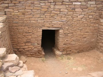 | |||
| This little door allows visitors to enter the inside of the pueblo, which is currently covered by a huge wood and metal roof to protect it from the elements. |
 | ||
| This kiva is known as the Painted Kiva, as it used to have intricate designs painted on the walls. They're gone now, though a portion was successfully removed and is in the museum. |
 |
| This is the firepit in the kiva. |
 |
| One last view of Lowry Pueblo. |
Once back outside, a short trail takes you to the Great Kiva - one of the largest ever found - which the experts believe was used for large gatherings instead of private ceremonial events.
 | ||
| I couldn't get all of it in one shot! |


These two stone figures were mysteries to archaelogists until a Hopi visitor informed them that they represented Winter and Summer People.
Mmmm Mmmm! Olathe Sweet Corn

First of all, I'd like to welcome follower #21, Wayne of Wayne's RV Travel Blog. Wayne and his wife Maureen are on their way to becoming full-time RV'ers, and will be doing it in a 22-foot trailer.
Second, I wanted to show you what we had with our hot dogs last night - Olathe sweet corn. One of the highlights of being in Colorado during the summer is the corn. It's famous. It's soooo good! And right now it's 5 for $1. So we ate 5.
Sunday, July 25, 2010
Hello from Priest Gulch

Site #92 at Priest Gulch Campground. It's not ON the Dolores River, but about 50 feet away from it.
There's a row of sites right on the river.
There's a row of sites right on the river.
Friday morning we enjoyed a last cup of coffee and breakfast at Ridgway State Park, and then leisurely packed up and left for Priest Gulch. It's only 72 miles, so we didn't have to hurry at all. The route took us up and over the Dallas Divide (the high country just north of the Sneffels Range), down to Placerville on the San Miguel River, then past Telluride, up and over Lizard Head Pass, and down to Rico. It's then 11 more miles to Priest Gulch Campground.
We stopped in Rico for lunch - there used to be a cafe/grill next to an old theater, and many years ago they made wonderful hamburgers. It's now closed; another grill a few doors down didn't open until noon (it was 11 am). We looked across the street, and noticed the Mine Shaft Inn, which had a coffee shop/tiny restaurant in front - it had a big sign in the window that said "FOOD." What a pleasant surprise this place was. Think of bed and breakfast without the breakfast. There are tables for 3-4 in the front room, then down the hall past one of the bedrooms is a kitchen with tables for 6 more people. We were greeted by the very friendly proprietor, who made us fresh coffee in a French press. It was soooo good. The food was limited: tamales, quiches, or burritos. It comes from the Hi Desert Bakery in Dolores, and is organic. Don had a beef enchilada quiche, and I had a broccoli quiche that had black olives and chilies in it. The couple who came in right after us had one of the tamales and one of the burritos, and we noticed they both were substantial in size.
After we came out of the inn, we noticed the darkening skies - and realized we'd better get on to Priest Gulch so we wouldn't have to set up in the rain. We made it just in time! We pulled into our site, got unhitched and leveled, and had just enough time to plug in the electricity and pull out the awning before the rain began. We experienced the biggest thunderstorm of the summer so far - huge, loud crashes of lightning and thunder and a driving rain that forced us inside since it was coming under the awning. The storm lasted about an hour - the roads of the campground turned into rivers and most of us had little lakes under our rigs. After it was all over our neighbor across the street motioned us over to come look at the river.


This is the very pretty view out our back window. There's a large patch of purple flowers (which are not Columbines but very similar).
We're going to be here until the 3rd of August - which is the day we head for home. Tomorrow we're going to go visit some Indian ruins - Hovenweep and Canyons of the Ancients National Monuments are southwest of here, with access to some of them by passenger car.
I'd like to welcome two more followers to Wanderlust - Amanda of Amanda's Veranda, and Rod and Loyce of Retired Rod. Thanks for being interested in my writings!
I'd like to welcome two more followers to Wanderlust - Amanda of Amanda's Veranda, and Rod and Loyce of Retired Rod. Thanks for being interested in my writings!
Tuesday, July 20, 2010
Black Canyon of the Gunnison National Park
Since we are camped only about 30 miles from Black Canyon of the Gunnison National Park, we decided to spend the morning there yesterday. It's a quick zip up the 550 to Montrose, then a few miles east on the 50 to the turnoff for the park. You make your way up a good-sized ridge (the edge of the Gunnison Uplift), pay your $15 entrance fee, and drive to the first overlook.
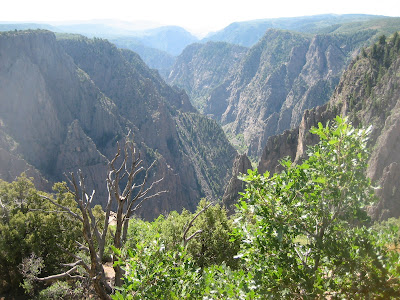


View east from Tomichi Point, the first viewpoint you get to after you enter the park.

One of the views from Gunnison Point, near the Visitor Center

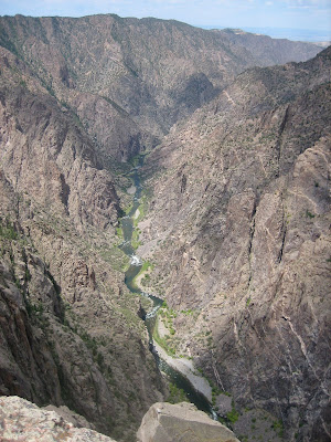
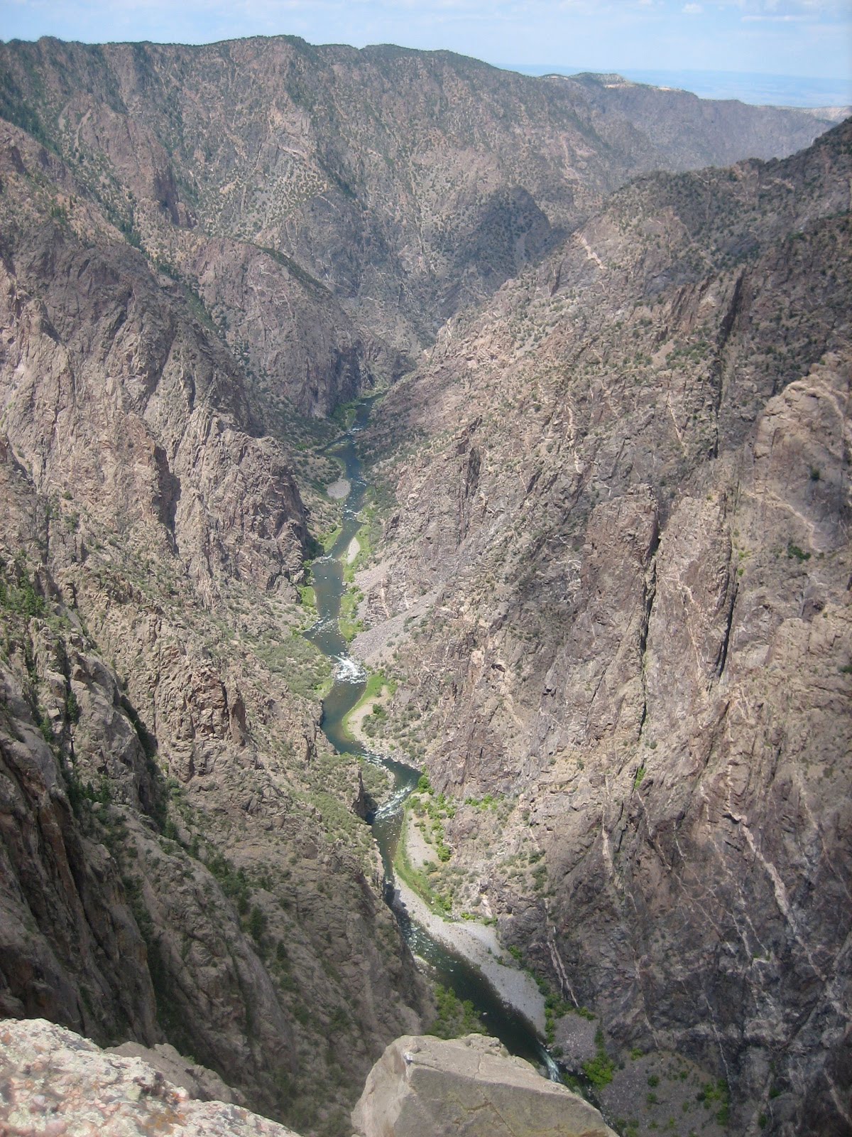
Looking down at the Gunnison River in the bottom of the canyon.

Another view of the Gunnison River

The canyon wall just north of the Visitor Center

Looking east from Gunnison Point

Looking down from Chasm View - this is where the canyon walls are closest together. A ranger who had just finished a geology talk (darn, we missed it!) said the North Rim is only 1100' away.

Looking northwest from Sunset View. You can see the western edge of Grand Mesa, along with two geological curiosities: the uncomformity above the gneiss/monozonite and below the Entrada sandstone and Red Canyon. The unconformity means that millions of years of rock were worn away on top of the gneiss/monozonite before the thin Entrada sandstone layer was laid down. You can barely see a portion of the Entrada at the top left at the center of the ridge, and another part of it at top right.

View from Cedar Point


We did NOT plan the lookalike blue shirts.
View west from Painted Wall View

This gnarled juniper reminded me of a bristlecone pine

The Painted Wall. It looks like this because molten pegmatite, the pinkish rock, came up and filled all the cracks in the gneiss. It solidified, making the wall even more impermeable.
By the time we'd finished viewing all the viewpoints - some with nice hikes to get to them - it was 12:30 and blazingly hot. We drove back into Montrose and enjoyed a nice lunch and lots of iced tea at Applebees before returning to our campsite in Ridgway. And, of course, Don spent another successful evening on the river.
Dallas Creek
July 17
It's just has hot here as it is in many parts of the country - and while we have electricity and can run the air, it's much nicer to head to high country so Don can fish and I can relax in the shade with a good book. We'd read in our little fishing guide that upper Dallas Creek had a small lake - so we decided to go up there. Dallas Creek's source is a cirque below Mt. Sneffels, so the road goes all the way up to the Blue Lakes trailhead.


It's just has hot here as it is in many parts of the country - and while we have electricity and can run the air, it's much nicer to head to high country so Don can fish and I can relax in the shade with a good book. We'd read in our little fishing guide that upper Dallas Creek had a small lake - so we decided to go up there. Dallas Creek's source is a cirque below Mt. Sneffels, so the road goes all the way up to the Blue Lakes trailhead.

Mt. Sneffels, 14,150'
We were unable to find the lake - which turned out to be a beaver pond we saw on our way back down - so we stopped at Willow Swamp Campground so Don could fish Dallas Creek. It isn't really a campground - just a parking area with dispersed places for people to set up, and Willow Swamp really isn't a swamp - it's a gorgeous meadow that runs along Dallas Creek.

Looking south over Willow Swamp towards Mt. Sneffels.
We stopped in the clearing just to the left of the middle center. I put my chair out in the shade and chased the shade for two hours. After lunch I told Don he had about one more hour until I lost the shade up on the hillside (can't put my chair on a slope!). It was hot, even at that altitude, so shade was a must.
He caught lots of fish - so it was yet another successful day!
Subscribe to:
Posts (Atom)